At Polaris Digitech Limited (PDL), we are essentially Land Surveyors and GIS consultants company in Nigeria. We are fully committed towards enhancing business solutions by harnessing the full potential of geospatial technology such as Location Intelligence and Mapping Services in order to satisfy our various clients in different business sectors. We are providers of Location Intelligence services, Google workspace for Business and Education. PDL creates high-quality services in various areas, such as Geographic Information Systems (GIS), consultations on GIS, land surveying, onboarding on Google cloud platform (GCP), location intelligence, and innovative technological applications that are functional throughout Nigeria. We boast of a team of professionals who are experts in the creation of different kinds of mapping solutions and Geo-enabled decision support systems. Our passion is what drives our delivery of best-in-class solutions and innovative technologies. When it comes to large-scale, ultra-high resolution and mapping, PDL remains your best shot at getting the right deployment of mapping solutions and an advanced mapping experience.
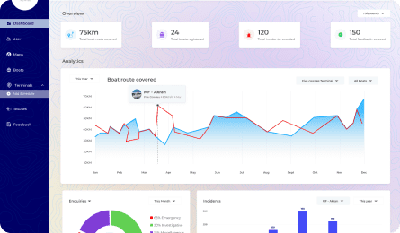
The Polaris Data Collector (PDC) is a data collection tool that enables real-time data gathering using custom-designed forms. Our Data collector is a computerized system that collects and stores data in an electronic form.
The Address Management Portal is a comprehensive platform designed and developed by Polaris Digitech Limited. It offers organizations a powerful tool for efficient address verification and management. With advanced features and user-friendly interface, it simplifies the process, enhances data accuracy, and improves overall customer experience.
The Risk-Geo platform, developed by Polaris Digitech Limited, is a robust and advanced solution designed to analyze and mitigate geographical risks. By combining powerful geospatial data analysis and intuitive visualization, it provides organizations with valuable insights for proactive risk management and decision-making, ensuring business resilience and growth.
At Polaris Digitech Limited, we provide a seamless platform that enables our clients to get the best experience when trying to integrate cloud-native applications with Google workspace (Gmail, Drive, Calendar, Meet) and Google Cloud Platform.
Polaris Digitech Limited being experts as Land Surveyors and GIS consultants provides training and capacity development in the underlisted areas; Software Training: MapInfo, Polaris Data Collector App, Bespoke Solutions Training. EGIS & Coverage Locator Application, Hardware Training.
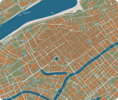
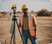
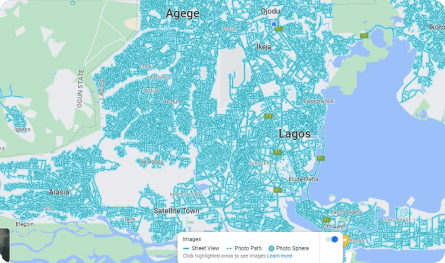
Mapping, survey, and drone services are important in various industries including construction, real estate, mining, oil and gas, and agriculture. Polaris Digitech Limited provides these services along with accurate data that can be used in decision-making and analysis.
Polaris Digitech Limited provide training and capacity development in the underlisted areas; Software Training: MapInfo, Polaris Data Collector App, Bespoke Solutions Training. EGIS & Coverage Locator Application, Hardware Training.
Full-stack software Development Company Build and remodel world-class digital products through a team of designers, developers, and strategy experts. All in one place!
Full-stack software Development Company Build and remodel world-class digital products through a team of designers, developers, and strategy experts. All in one place!
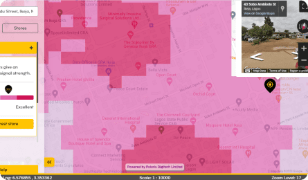
The MTNN Coverage Locator Application is a location intelligence solution which enables MTNN subscribers & retail staff at the walk-in centers to identify network coverage signal levels and report areas of poor network coverage by performing a street level search on the web map. The application is to help drive 5G acceleration and sales of 5G devices to potential 5G customers.